Inquire: Call 0086-755-23203480, or reach out via the form below/your sales contact to discuss our design, manufacturing, and assembly capabilities.
Quote: Email your PCB files to Sales@pcbsync.com (Preferred for large files) or submit online. We will contact you promptly. Please ensure your email is correct.
Notes: For PCB fabrication, we require PCB design file in Gerber RS-274X format (most preferred), *.PCB/DDB (Protel, inform your program version) format or *.BRD (Eagle) format. For PCB assembly, we require PCB design file in above mentioned format, drilling file and BOM. Click to download BOM template To avoid file missing, please include all files into one folder and compress it into .zip or .rar format.
Meta:Learn GPS Module Arduino NEO-6M setup from a PCB engineer. Step-by-step wiring, NMEA parsing, real projects, datasheets & optimization tips for professionals.
As a PCB engineer working with embedded systems, I’ve integrated dozens of GPS modules into various projects over the years. The NEO-6M GPS module stands out as one of the most reliable and cost-effective solutions for Arduino location tracking applications. Whether you’re designing a vehicle tracker, building autonomous navigation systems, or developing IoT devices, understanding how to properly interface this module can save you countless debugging hours.
The NEO-6M has become the go-to choice for hobbyists and professionals alike due to its excellent balance of performance, power consumption, and affordability. In this comprehensive guide, I’ll walk you through everything you need to know about implementing GPS module Arduino projects, from basic wiring to advanced troubleshooting techniques.
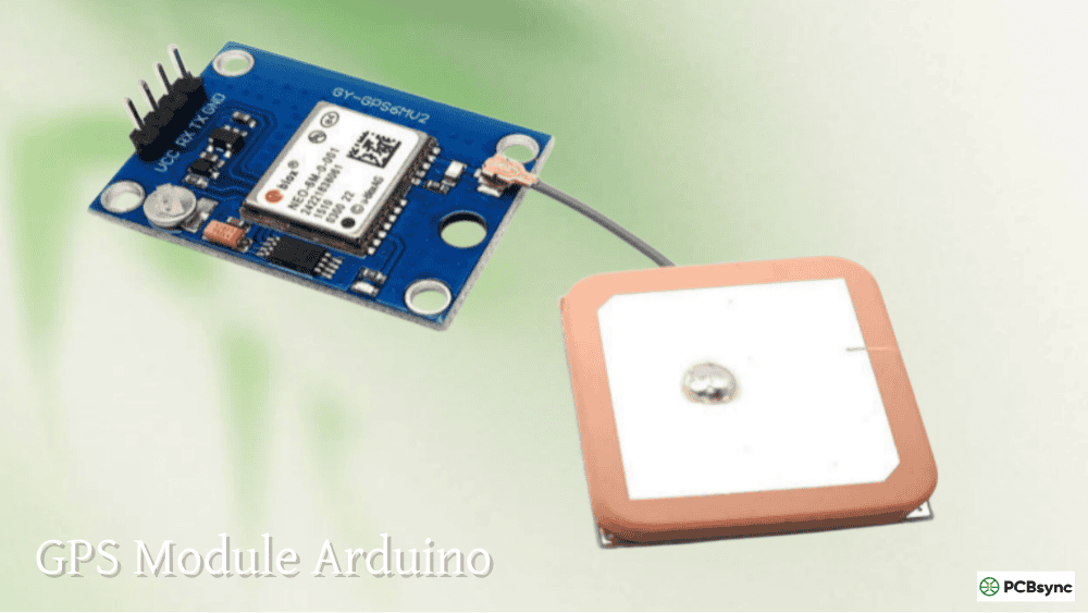
The NEO-6M GPS module is built around the u-blox NEO-6M chipset, a high-performance GPS receiver designed for demanding location-based applications. From a hardware perspective, understanding the internal architecture helps you make better design decisions for your PCB layouts.
Key Technical Specifications:
Specification
Value
Engineering Notes
GPS Chipset
u-blox NEO-6M (UBX-G6010)
AEC-Q100 qualified for automotive applications
Satellite Tracking
Up to 22 satellites
50 tracking channels simultaneously
Sensitivity
-161 dBm
Industry-leading weak signal detection
Position Accuracy
2.5 meters (typical)
Can improve with SBAS/WAAS augmentation
Operating Voltage
2.7V – 3.6V (chip)
Module includes 5V-tolerant logic
Current Consumption
45mA (active) / 11mA (PSM)
Power Save Mode ideal for battery designs
Communication Protocol
UART (default 9600 baud)
Configurable from 4800 to 230400 baud
Update Rate
1Hz (default) / 5Hz (max)
Configurable via UBX protocol commands
Cold Start Time
~27 seconds
Without EEPROM data
Warm Start Time
~25 seconds
With partial satellite data
Hot Start Time
~1 second
Recent position data available
Operating Temperature
-40°C to +85°C
Suitable for outdoor installations
Module Components Breakdown
When examining the NEO-6M module PCB, you’ll find several critical components that contribute to its functionality:
1. GPS Receiver Chip The u-blox NEO-6M chipset is the brain of the module. It processes signals from GPS satellites using sophisticated algorithms for trilateration. The chip supports multiple positioning systems including GPS and GLONASS (on certain variants).
2. Voltage Regulator (MICREL MIC5205) This ultra-low dropout 3.3V regulator allows the module to accept 5V input directly from Arduino boards. The regulator provides clean, stable power to the sensitive GPS receiver circuitry. When designing custom GPS integrations on your PCB, pay attention to power supply noise – GPS receivers are particularly susceptible to interference from switching regulators.
3. Battery-Backed EEPROM System The module includes an HK24C32 4KB EEPROM chip paired with a rechargeable button battery. This configuration stores:
Real-time clock data
Last known satellite positions (ephemeris data)
Module configuration settings
Satellite almanac information
The battery maintains this data for approximately two weeks without external power, enabling faster “hot starts” when the system reboots.
4. Ceramic Patch Antenna Most NEO-6M modules come with a 25x25x4mm ceramic active antenna connected via U.FL connector. The antenna includes an LNA (Low Noise Amplifier) to boost weak satellite signals. For production designs, consider external antennas with longer cables for flexible mounting options, especially in metal enclosures.
5. Status Indicators
Power LED: Indicates module is receiving power
Position Fix LED: Blinks once per second when satellite lock is achieved; steady off when searching
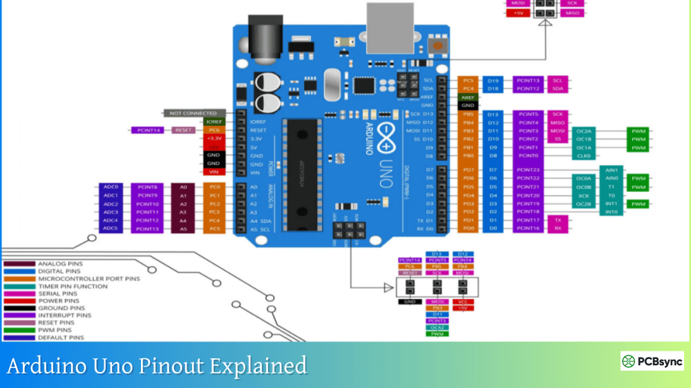
GPS Module Arduino Pinout and Connection Guide
Understanding the Pin Configuration
The NEO-6M module typically features four main pins for interfacing:
Pin Name
Function
Connection
Voltage Level
VCC
Power Supply
Arduino 5V or 3.3V
5V tolerant
GND
Ground
Arduino GND
–
TXD
Transmit Data
Arduino RX pin (Software Serial)
3.3V logic (5V tolerant)
RXD
Receive Data
Arduino TX pin (Optional)
3.3V logic (5V tolerant)
Important Engineering Notes:
The RXD pin is optional for basic GPS reception. You only need it if you want to send configuration commands to the module.
While the module is 5V tolerant, best practice for production designs includes using voltage dividers or level shifters on the Arduino TX to GPS RX connection.
The module draws approximately 45mA, which is within Arduino’s power supply capability.
Proper Wiring for Arduino Integration
When connecting the GPS module Arduino system, follow this configuration:
For Arduino Uno/Nano:
NEO-6M Module → Arduino Board
VCC → 5V
GND → GND
TX → Digital Pin 4 (Software Serial RX)
RX → Digital Pin 3 (Software Serial TX) [Optional]
Critical Wiring Considerations:
Avoid Hardware Serial Pins: Don’t connect to Arduino pins 0 and 1 (hardware serial), as these are used for USB communication and programming. Use SoftwareSerial library instead.
Power Supply Filtering: Add a 100µF electrolytic capacitor and 0.1µF ceramic capacitor near the VCC pin to filter power supply noise. GPS receivers are sensitive to voltage ripple.
Antenna Placement: The ceramic antenna must have clear sky view. Metal enclosures will block signals entirely. If you need to mount the module in a metal case, route an external antenna cable to the outside.
Ground Plane Considerations: On custom PCBs, provide a solid ground plane under the GPS module to reduce interference and improve sensitivity.
Programming GPS Module Arduino Projects
Essential Arduino Libraries
For professional-grade GPS implementations, you’ll need the following libraries:
1. TinyGPS++ Library (Recommended)
Developed by Mikal Hart
Efficient NMEA sentence parsing
Minimal memory footprint
Extensive data extraction methods
Installation: Arduino IDE → Sketch → Include Library → Manage Libraries → Search “TinyGPS++”
2. SoftwareSerial Library
Built into Arduino IDE
Creates virtual serial ports on digital pins
Essential for preserving hardware serial for debugging
Basic GPS Data Acquisition Code
Here’s production-ready code for reading GPS data:
#include <TinyGPS++.h>
#include <SoftwareSerial.h>
// Define GPS connection pins
static const int RXPin = 4, TXPin = 3;
static const uint32_t GPSBaud = 9600;
// Create TinyGPS++ object
TinyGPSPlus gps;
// Create software serial connection
SoftwareSerial gpsSerial(RXPin, TXPin);
void setup() {
Serial.begin(9600);
gpsSerial.begin(GPSBaud);
Serial.println(“NEO-6M GPS Module Initialized”);
Serial.println(“Waiting for satellite lock…”);
}
void loop() {
// Read data from GPS module
while (gpsSerial.available() > 0) {
gps.encode(gpsSerial.read());
if (gps.location.isUpdated()) {
// Display location data
Serial.print(“Latitude: “);
Serial.print(gps.location.lat(), 6);
Serial.print(” | Longitude: “);
Serial.print(gps.location.lng(), 6);
// Additional useful parameters
Serial.print(” | Altitude: “);
Serial.print(gps.altitude.meters());
Serial.print(“m”);
Serial.print(” | Speed: “);
Serial.print(gps.speed.kmph());
Serial.print(“km/h”);
Serial.print(” | Satellites: “);
Serial.print(gps.satellites.value());
Serial.print(” | HDOP: “);
Serial.println(gps.hdop.hdop());
}
}
}
Understanding NMEA Sentence Protocol
The NEO-6M transmits data using NMEA 0183 protocol – a standard format for marine electronics. Understanding this protocol is crucial for debugging and advanced implementations.
1. Vehicle Tracking System Combine NEO-6M with GSM modules (SIM800L/SIM900) to create real-time tracking systems. The Arduino reads GPS coordinates and transmits them via SMS or GPRS to a cloud server.
2. Data Logger for Route Recording Interface with SD card modules to log GPS coordinates, speed, and altitude at regular intervals. Useful for mapping, surveying, and athletic training applications.
3. Autonomous Navigation Feed GPS data to navigation algorithms for robotics and drone applications. Calculate bearing and distance to waypoints for autonomous path following.
4. Geofencing Systems Create virtual boundaries and trigger alerts when devices enter or exit designated areas. Common in fleet management and asset protection.
5. Time Synchronization GPS satellites broadcast extremely accurate time signals. Use the NEO-6M as a precision time source for data acquisition systems and scientific instrumentation.
Troubleshooting Common GPS Module Arduino Issues
From my experience on the engineering bench, here are the most common problems and their solutions:
Issue 1: No Satellite Lock (LED Not Blinking)
Symptoms: Position Fix LED remains off, no valid GPS data
Solutions:
Location, location, location: GPS requires clear sky view. Move the module outdoors or near a window. Indoor operation is nearly impossible without an external antenna.
Initial acquisition time: First-time use can take 5-15 minutes to download almanac data from satellites.
Battery backup: If the backup battery is dead, every power cycle requires a cold start. Replace the CR1220 battery.
Antenna connection: Verify the U.FL antenna connector is properly seated. A loose connection will prevent signal reception.
Issue 2: Garbage Data in Serial Monitor
Symptoms: Random characters, corrupted text
Solutions:
Baud rate mismatch: Ensure both the GPS module and software serial are set to 9600 baud.
Power supply issues: Check for voltage drops. Use a multimeter to verify stable 5V at the VCC pin.
Wiring errors: Verify TX/RX connections are correct and not swapped.
Issue 3: Intermittent GPS Fixes
Symptoms: Location data appears then disappears
Solutions:
Electromagnetic interference: Keep the module away from switching power supplies, motors, and WiFi/Bluetooth modules.
Obstructed sky view: Even temporary obstructions (trees, buildings) can cause signal loss.
Symptoms: Position shows incorrect location or jumps erratically
Solutions:
Multipath interference: Signals bouncing off buildings create position errors. Use external antenna with ground plane.
Atmospheric conditions: Heavy cloud cover or ionospheric disturbances can degrade accuracy.
Selective Availability: Modern GPS is accurate to 2.5m typically, but can vary based on satellite geometry.
Performance Optimization Tips for GPS Designs
Hardware Improvements
1. Antenna Selection The stock ceramic antenna works well for basic applications, but external antennas with magnetic mounts provide superior performance. Look for antennas with:
25-28dB gain
Waterproof housing (IP67 rated)
3-5 meter cable length
SMA or MCX connectors
2. Power Supply Design For battery-powered designs:
Use LDO regulators instead of switching converters near GPS module
Add LC filters on power rails
Implement power sequencing to allow proper GPS initialization
Understanding how the NEO-6M compares to other modules helps in project selection:
Feature
NEO-6M
NEO-7M
NEO-M8N
Alternatives (GY-GPS6MV2)
GPS Chipset
UBX-G6010
UBX-G7020
UBX-M8030
Same as NEO-6M
Sensitivity
-161dBm
-162dBm
-167dBm
-161dBm
Position Accuracy
2.5m
2.0m
2.0m
2.5m
Satellite Systems
GPS
GPS + GLONASS
GPS + GLONASS + Galileo + BeiDou
GPS
Update Rate
5Hz max
10Hz max
18Hz max
5Hz max
Cold Start
27s
26s
26s
27s
Current Draw
45mA
40mA
31mA
45mA
Price Range
$5-10
$8-15
$15-25
$5-8
Best Use Case
Budget projects
Better sensitivity
Multi-GNSS precision
Low-cost backup
Professional Integration Best Practices
Production Considerations
When moving from prototype to production:
1. Electromagnetic Compatibility (EMC)
Add ferrite beads on power lines
Implement proper grounding strategies
Shield the GPS module if necessary
Test with certified EMC labs for commercial products
2. Environmental Protection
Use conformal coating on PCB
Specify IP-rated enclosures for outdoor use
Account for temperature effects on crystal oscillator
Implement ESD protection on exposed connectors
3. Quality Assurance Testing
Test satellite acquisition in various conditions
Verify accuracy with known reference points
Measure current consumption across all modes
Validate communication protocols with production firmware
Cost Optimization Strategies
From a manufacturing perspective:
Volume Pricing: NEO-6M modules are available for $3-5 in quantities over 100 units
Antenna Options: Generic ceramic antennas can reduce BOM cost by 40%
PCB Integration: Consider bare GPS chips for high-volume production
Alternative Modules: GY-GPS6MV2 offers similar performance at lower cost
Frequently Asked Questions
1. How long does it take for the NEO-6M to get the first GPS fix?
The acquisition time depends on the module’s state:
Cold start (no stored data): 27-45 seconds
Warm start (partial data): 25-30 seconds
Hot start (recent data): 1-5 seconds
If you’re experiencing longer acquisition times, ensure the backup battery is functioning and the module has clear sky view. Initial acquisition can take 5-15 minutes to download full almanac data. For production applications, consider implementing Assisted GPS (A-GPS) to reduce time-to-first-fix.
2. Can I use the NEO-6M GPS module indoors?
Generally, no. GPS signals are extremely weak (approximately -130dBm at ground level) and cannot penetrate building materials effectively. Concrete, metal structures, and even energy-efficient windows block GPS signals. For indoor positioning, you’ll need:
An external antenna mounted outdoors with cable routed inside
Alternative positioning technologies (WiFi, Bluetooth beacons, UWB)
GPS signal repeaters (expensive and complex)
Some engineers report limited success near large windows, but this is unreliable for production applications.
3. Why is my GPS showing incorrect coordinates or jumping around?
Position instability typically results from:
Low satellite count: Fewer than 4 satellites provides poor geometry. Check the satellite count in your code.
Multipath interference: Signals bouncing off buildings create ghost reflections. Use an external antenna with ground plane.
Electromagnetic interference: WiFi, Bluetooth, and switching power supplies can jam GPS reception.
Implement position filtering in software using Kalman filters or simple averaging to smooth erratic readings.
4. What’s the difference between NEO-6M and NEO-7M modules?
The NEO-7M is the next generation offering:
Improved sensitivity (-162dBm vs -161dBm)
GLONASS support in addition to GPS (more satellites visible)
Better urban canyon performance
Lower power consumption (40mA vs 45mA)
Faster maximum update rate (10Hz vs 5Hz)
For new designs, the NEO-7M or newer NEO-M8N provides better performance at marginally higher cost. However, the NEO-6M remains excellent value for non-critical applications where occasional accuracy variations are acceptable.
5. How can I improve GPS accuracy beyond the 2.5-meter specification?
Several techniques improve accuracy:
Hardware Methods:
Use external active antenna with ground plane
Implement differential GPS (DGPS) with base station
Enable SBAS/WAAS augmentation systems
Average multiple position readings over time
Software Methods:
Implement Kalman filtering to smooth position data
Use velocity information to predict position
Combine GPS with IMU (Inertial Measurement Unit) for sensor fusion
Apply geodetic corrections for your local area
For centimeter-level accuracy, consider RTK (Real-Time Kinematic) GPS modules, though these cost significantly more ($100-300) and require complex setup with base stations.
Conclusion
The GPS module Arduino combination using the NEO-6M provides an excellent entry point into location-based embedded systems. Whether you’re prototyping vehicle trackers, building navigation systems, or developing IoT location services, understanding the technical details presented here will accelerate your development process.
From proper hardware integration and PCB layout considerations to software optimization and troubleshooting techniques, successful GPS implementations require attention to multiple engineering disciplines. The NEO-6M’s balance of cost, performance, and ease of integration makes it ideal for both learning and production applications.
Remember that GPS technology, while incredibly powerful, has fundamental limitations. Always design your systems with realistic expectations about accuracy, acquisition time, and environmental constraints. Proper antenna placement, power supply design, and software implementation separate successful GPS products from problematic ones.
As you develop your GPS module Arduino projects, reference the datasheets, use the recommended libraries, and don’t hesitate to experiment with different configurations. The skills you develop working with the NEO-6M will transfer directly to more advanced GPS and GNSS modules as your projects evolve.
For complex applications requiring enhanced accuracy, multi-constellation support, or specialized features, investigate the NEO-M8N and newer generations. However, for the majority of hobbyist and professional projects, the NEO-6M remains an outstanding choice that delivers reliable performance at an unbeatable price point.
Happy tracking, and may your satellites always be visible!
Inquire: Call 0086-755-23203480, or reach out via the form below/your sales contact to discuss our design, manufacturing, and assembly capabilities.
Quote: Email your PCB files to Sales@pcbsync.com (Preferred for large files) or submit online. We will contact you promptly. Please ensure your email is correct.
Notes: For PCB fabrication, we require PCB design file in Gerber RS-274X format (most preferred), *.PCB/DDB (Protel, inform your program version) format or *.BRD (Eagle) format. For PCB assembly, we require PCB design file in above mentioned format, drilling file and BOM. Click to download BOM template To avoid file missing, please include all files into one folder and compress it into .zip or .rar format.


