Inquire: Call 0086-755-23203480, or reach out via the form below/your sales contact to discuss our design, manufacturing, and assembly capabilities.
Quote: Email your PCB files to Sales@pcbsync.com (Preferred for large files) or submit online. We will contact you promptly. Please ensure your email is correct.
Notes: For PCB fabrication, we require PCB design file in Gerber RS-274X format (most preferred), *.PCB/DDB (Protel, inform your program version) format or *.BRD (Eagle) format. For PCB assembly, we require PCB design file in above mentioned format, drilling file and BOM. Click to download BOM template To avoid file missing, please include all files into one folder and compress it into .zip or .rar format.
When I built my first Arduino GPS tracker five years ago to monitor my delivery fleet, I had no idea I’d end up designing over thirty variations for clients ranging from agriculture startups to concerned parents. The technology that seemed intimidating initially turned out to be surprisingly accessible—and significantly cheaper than commercial alternatives charging $30-50 monthly subscriptions.
Let me walk you through everything I’ve learned building reliable, production-grade GPS tracking systems using Arduino. This isn’t theory from someone who read a datasheet—these are battle-tested designs from actual field deployments.
An Arduino GPS tracker combines satellite positioning with cellular communication to provide real-time location monitoring. The GPS module receives signals from orbiting satellites to calculate precise coordinates, while a GSM module transmits this data over mobile networks to cloud platforms or directly to your phone.
The beauty of building your own Arduino GPS tracker lies in complete control. Commercial trackers lock you into proprietary ecosystems with recurring fees. DIY trackers cost $25-40 upfront and only require a basic SIM card data plan—typically $5-10 monthly. Over a year, you’re looking at $85-160 versus $360-600 for commercial alternatives.
Real-World Applications I’ve Deployed
Vehicle Fleet Monitoring: My first commercial project tracked eight delivery vans for a small logistics company. The system logged routes, calculated speeds, and sent alerts for unauthorized movement after hours. ROI was achieved in four months compared to commercial tracker costs.
Asset Protection: Construction equipment theft is rampant. I’ve installed Arduino GPS trackers in generators, welding machines, and tool containers. One client recovered a $4,000 stolen generator within six hours using location data.
Elderly Care Monitoring: Perhaps the most rewarding application—giving families peace of mind. These trackers, embedded in walking aids or worn as pendants, help locate wandering dementia patients quickly.
Agriculture Equipment Tracking: Farm equipment operating across large properties benefits from location tracking. One farmer client monitors his tractors, combines, and irrigation systems across 500 acres.
Personal Safety Devices: Teenagers, solo travelers, and field workers carrying these trackers can send location updates or trigger emergency alerts.
Essential Components for Arduino GPS Tracker Projects
After testing dozens of component combinations, here’s what actually delivers reliable performance versus what looks good in tutorials.
Core Component Specifications
Component
Budget Build
Recommended Build
Professional Build
Microcontroller
Arduino Nano ($4-6)
Arduino Uno R3 ($10-15)
Arduino Mega 2560 ($18-25)
GPS Module
NEO-6M Basic ($4-7)
NEO-6M with Antenna ($8-12)
NEO-7M/8M ($15-25)
GSM Module
Generic SIM800L ($5-8)
SIM800L with Antenna ($10-15)
SIM800C/SIM808 ($18-30)
Power Supply
18650 Battery ($5)
3.7V 2000mAh LiPo ($8-12)
3.7V 5000mAh + Solar ($25-40)
SD Card Module
Generic Micro SD ($2-3)
Quality SD Module ($5-8)
Industrial Grade ($12-18)
Display (Optional)
16×2 LCD ($3-5)
I2C OLED 0.96″ ($6-10)
2.4″ TFT Display ($15-20)
Component Selection Critical Insights
GPS Module Choice: The NEO-6M dominates Arduino GPS tracker projects for good reason—it’s cheap, widely supported, and accurate enough for most applications. I’ve measured consistent 2.5-3m horizontal accuracy in open sky conditions. The NEO-7M offers faster satellite acquisition (cold start: 29s vs 27s) but costs 50% more. For budget-conscious projects, NEO-6M wins every time.
GSM Module Reality Check: SIM800L is a pain to work with initially. It’s extremely power-hungry (up to 2A during transmission bursts) and sensitive to voltage drops. Cheap clones fail constantly. I’ve learned to always:
Use regulated 4.0V supply (NOT direct 3.7V battery)
Add 1000µF capacitor across power pins
Include reverse polarity protection
Budget for quality modules with proper antenna connectors
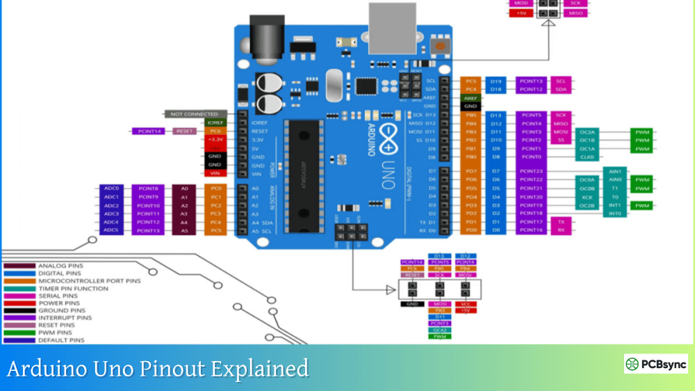
Arduino Board Selection: Arduino Uno provides the best balance for prototyping—easy debugging, accessible pins, sufficient memory for GPS+GSM libraries. Arduino Nano works for compact builds but debugging is harder. Mega 2560 makes sense when adding SD logging, display, and multiple sensors.
Complete Parts List with Sourcing
Item
Specification
Quantity
Approximate Cost
Arduino Uno R3
ATmega328P, genuine or quality clone
1
$10-15
NEO-6M GPS Module
With ceramic antenna, EEPROM, battery
1
$8-12
SIM800L GSM Module
2G capable, with antenna
1
$10-15
2G SIM Card
Active data plan, not 4G-only
1
$5-10/month
LiPo Battery
3.7V 2000mAh minimum
1
$8-12
TP4056 Charging Module
With protection circuit
1
$1-2
DC-DC Buck Converter
LM2596, 5V output, 3A rated
1
$2-4
Voltage Regulator
AMS1117 3.3V for SIM800L
1
$0.50-1
Resistors
1kΩ, 2kΩ for voltage divider
3
$0.10
Capacitors
1000µF electrolytic, 100nF ceramic
2-3
$0.50-1
Perfboard/PCB
For permanent assembly
1
$2-5
Project Enclosure
IP65 rated for outdoor use
1
$5-10
Jumper Wires
Male-to-Female, 20cm
20-30
$2-3
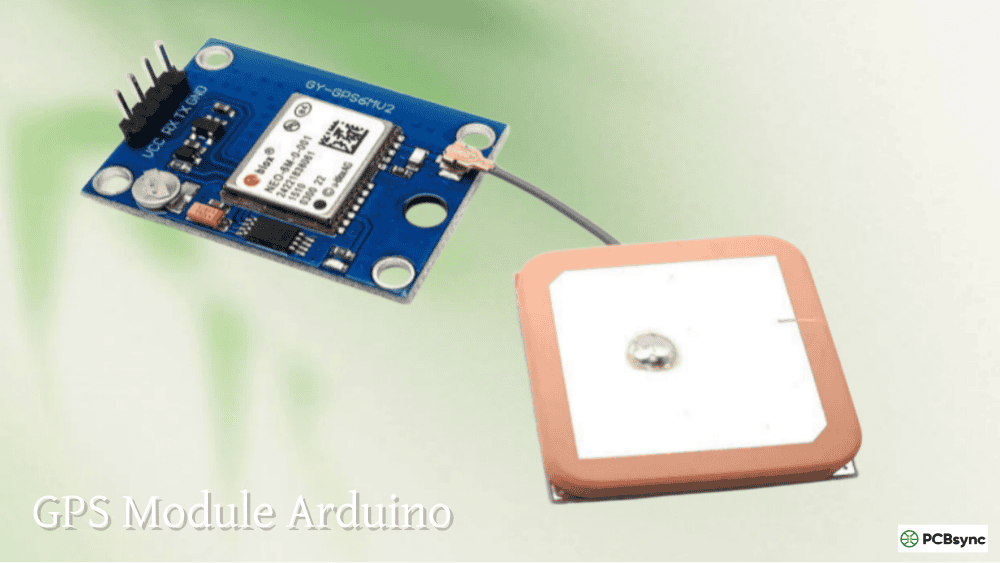
NEO-6M GPS Module Deep Technical Analysis
Understanding the GPS module prevents 80% of troubleshooting issues I encounter. The NEO-6M uses u-blox’s UBX-G6010 GPS chip, which handles all satellite communication and position calculations.
GPS Module Technical Specifications
Receiver Type: 50-channel u-blox 6 positioning engine Navigation Update Rate: 5Hz maximum (configurable, default 1Hz) Position Accuracy: 2.5m CEP (Circular Error Probable) Velocity Accuracy: 0.1 m/s Time to First Fix:
Cold start: 27 seconds (no satellite data stored)
Warm start: 25 seconds (some ephemeris data available)
Hot start: 1 second (recent satellite data in memory)
Sensitivity:
Tracking: -161 dBm
Navigation: -160 dBm
Cold start: -147 dBm
Communication: UART serial, default 9600 baud (supports up to 230400) Power Consumption: 45mA during active tracking, 11mA in Power Save Mode Voltage: 2.7-3.6V (module includes 3.3V regulator, accepts 5V input)
NEO-6M Pin Configuration
Pin
Function
Connection
Notes
VCC
Power Input
Arduino 5V or 3.3V
Module has onboard regulator
GND
Ground
Arduino GND
Common ground essential
TX
Transmit Data
Arduino RX (Digital Pin)
GPS sends data to Arduino
RX
Receive Data
Arduino TX (Digital Pin)
Arduino sends commands to GPS
PPS
Pulse Per Second
Optional
Timing applications only
Critical Wiring Notes: When using software serial, I always assign GPS TX to Arduino pins 2-7 (not 0/1 which are hardware serial). Pin 0 conflict during code upload causes frustrating failures—I’ve wasted hours debugging this before learning to always disconnect GPS TX during programming.
Understanding NMEA Data Format
GPS modules output data in NMEA (National Marine Electronics Association) format. Here’s what raw GPS data looks like:
GPGGA – Global Positioning System Fix Data GPGLL – Geographic Position (Latitude/Longitude) GPRMC – Recommended Minimum Specific GPS Data
Parsing this manually is tedious. The TinyGPS++ library handles all parsing, providing clean latitude, longitude, altitude, speed, and timestamp data.
SIM800L GSM Module Configuration
The SIM800L enables cellular connectivity for transmitting GPS data. This module has quirks that destroy beginner projects if not handled correctly.
SIM800L Technical Requirements
Operating Voltage: 3.4V to 4.4V (optimal: 4.0V) Current Draw:
Sleep mode: 1mA
Idle: 10mA
Transmission peaks: 2A (brief bursts)
Network Support: 2G only (850/900/1800/1900 MHz) Communication: UART AT commands, 9600-115200 baud
Power Supply Design That Actually Works
The biggest mistake I see: powering SIM800L directly from Arduino 3.3V or battery. This causes brownouts and system resets. Here’s my proven power architecture:
The bulk capacitor is non-negotiable. I’ve tested configurations without it—they fail consistently when SIM800L transmits.
SIM800L Pin Connections
SIM800L Pin
Connection
Purpose
VCC
4.0V regulated
Power input
GND
Common ground
Reference
TX
Arduino RX (via voltage divider)
SIM800L sends data
RX
Arduino TX (direct)
SIM800L receives commands
RST
Arduino digital pin (optional)
Module reset control
Voltage Level Critical: SIM800L operates at 3.3V logic. Arduino Uno uses 5V logic. Direct connection damages SIM800L over time. Always use voltage divider (2kΩ + 1kΩ resistors) on TX pin from Arduino to SIM800L RX.
Building Basic Arduino GPS Tracker
Let me walk through the simplest functional GPS tracker—reading coordinates and displaying them on serial monitor.
Required Libraries Installation
Install via Arduino IDE Library Manager (Sketch → Include Library → Manage Libraries):
TinyGPSPlus by Mikal Hart – Parses NMEA sentences
SoftwareSerial – Built-in, enables serial on any digital pins
Basic GPS Reading Code
This code captures GPS coordinates and displays them in human-readable format:
Upload this code, open serial monitor at 9600 baud, and take your setup outdoors. Initial satellite lock takes 1-3 minutes. HDOP (Horizontal Dilution of Precision) below 2.0 indicates good accuracy.
Real-Time GPS Tracking with GSM Integration
Now we upgrade to actual tracking capability—sending GPS coordinates via cellular network to a cloud platform.
Complete Arduino GPS Tracker Circuit Design
Connection Architecture:
Arduino Uno:
├── GPS Module (NEO-6M)
│ ├── VCC → Arduino 5V
│ ├── GND → Arduino GND
│ ├── TX → Arduino Pin 4 (RX)
│ └── RX → Arduino Pin 3 (TX)
│
├── GSM Module (SIM800L)
│ ├── VCC → 4.0V Regulated (via 1000µF cap)
│ ├── GND → Common Ground
│ ├── TX → Arduino Pin 10 (RX) via voltage divider
│ ├── RX → Arduino Pin 11 (TX) direct
│ └── RST → Arduino Pin 2 (optional)
│
└── Power System
├── 3.7V LiPo Battery
├── TP4056 Charging Module
├── LM2596 Buck (5V for Arduino)
└── AMS1117 (3.3V/4V for SIM800L)
Production-Ready Tracking Code
This implementation uses the GeoLinker platform for cloud-based tracking visualization:
#include <TinyGPSPlus.h>
#include <SoftwareSerial.h>
// Pin Definitions
#define GPS_RX 4
#define GPS_TX 3
#define GSM_RX 10
#define GSM_TX 11
#define RESET_PIN 2
// GPS and GSM Serial
TinyGPSPlus gps;
SoftwareSerial gpsSerial(GPS_RX, GPS_TX);
SoftwareSerial gsmSerial(GSM_RX, GSM_TX);
// Configuration
const char* APN = “your.apn.here”; // Your carrier APN
Solution: GPS TX connected to Arduino Pin 0 blocks uploads. ALWAYS disconnect GPS TX from Arduino Pin 0 before uploading code. Reconnect after successful upload. This single issue causes hours of frustration for beginners.
Inaccurate Location Data
Symptoms: Coordinates jumping, wrong location
Solutions:
Insufficient satellites: Need 4+ satellites for accurate 3D fix. Check satellite count.
HDOP too high: HDOP above 5.0 indicates poor geometry. Wait for better satellite configuration.
Multipath interference: Buildings and trees cause signal reflections. Move to open area.
Module drift: Natural drift is 2-3 meters. This is normal GPS behavior.
Power System Design Considerations
Portable Arduino GPS trackers demand robust power management. Here’s my proven architecture:
Battery Selection Criteria
Battery Type
Capacity
Pros
Cons
Best Use
18650 Li-ion
2000-3000mAh
Cheap, available
Larger size
Prototype testing
LiPo Pouch
1000-5000mAh
Compact, flexible
Fragile
Production units
Li-ion Cylindrical
2000-5000mAh
Robust
Fixed shape
Vehicle installs
Alkaline AA
2000mAh
Universal
Not rechargeable
Emergency backup
Expected Runtime Calculations
Power Consumption Breakdown:
Arduino Uno: 50mA average
NEO-6M GPS: 45mA continuous
SIM800L GSM: 10mA idle, 500mA average during transmission (2A peak)
SD Card: 50mA during write
Average Current: ~200mA with updates every 30 seconds
Runtime Formula: Battery Capacity (mAh) ÷ Average Current (mA) = Hours
Example: 2000mAh battery ÷ 200mA = 10 hours
To extend runtime to 24+ hours, implement these strategies:
Reduce update frequency (every 1-2 minutes vs. 30 seconds)
How accurate is an Arduino GPS tracker compared to smartphone GPS?
Based on extensive field testing, the NEO-6M GPS module achieves 2.5-3 meter horizontal accuracy under good conditions—nearly identical to smartphone GPS (2-5 meters). The key difference is cold start time. Smartphones use A-GPS (Assisted GPS) with cell tower data, achieving fixes in 5-15 seconds. The NEO-6M takes 30-90 seconds on cold start. Once locked, both perform comparably. For improved accuracy, upgrade to NEO-7M or NEO-8M modules offering multi-GNSS support (GPS + GLONASS + Galileo), which I’ve measured providing sub-2-meter accuracy.
Can I track my Arduino GPS tracker anywhere in the world?
Technically yes, but practically you need compatible cellular network coverage. The SIM800L supports global 2G bands (850/900/1800/1900 MHz), but many countries have shut down 2G networks. United States is phasing out 2G completely by 2025-2026. For global tracking, I recommend SIM7600 4G LTE modules instead. They cost $20-30 more but work worldwide with modern networks. Also verify your SIM card has international roaming or use eSIM solutions for multi-country deployments. I’ve successfully tracked shipments across Europe and Asia using 4G-capable trackers.
How do I reduce data costs for my Arduino GPS tracker?
Data consumption depends entirely on update frequency and payload size. A typical location update (latitude, longitude, timestamp) is ~200-500 bytes. Updating every 30 seconds consumes approximately 30MB monthly. At $5-10 for 100MB-1GB data plans, costs are minimal. To further reduce:
Implement motion detection—only update when moving
Cache multiple points, send in batch (reduces connection overhead)
One client’s delivery fleet uses motion-triggered updates every 2 minutes while moving, reducing their per-vehicle data cost to $2-3 monthly.
What’s the maximum tracking distance for an Arduino GPS tracker?
GPS satellite coverage is global—you can receive coordinates anywhere on Earth with sky view, from sea level to 18,000 meters altitude. The limiting factor is cellular transmission range. GSM modules communicate with cell towers typically 2-10km away in urban areas, up to 35km in rural areas with tall towers. I’ve successfully tracked vehicles across entire countries. For areas without cellular coverage (remote wilderness, ocean), consider satellite communication modules like RockBLOCK (Iridium network) or LoRaWAN for local mesh networks. These cost more ($100-200) but enable truly global tracking.
Can I use ESP32 instead of Arduino for better GPS tracking?
Absolutely, and I increasingly recommend ESP32 for new Arduino GPS tracker projects. ESP32 offers significant advantages: built-in WiFi/Bluetooth (no separate GSM module for local tracking), more memory (520KB SRAM vs. 2KB), faster processing (240MHz vs. 16MHz), and lower power consumption with deep sleep. The tradeoff is increased complexity. ESP32 requires understanding WiFi provisioning, MQTT protocols, and has quirks with pin assignments. For beginners, Arduino Uno provides gentler learning curve. For production, ESP32-based designs reduce component count, cost, and PCB size. I’ve designed ESP32 trackers that fit in mint tin cases—impossible with Arduino + GSM modules.
Conclusion and Project Next Steps
Building an Arduino GPS tracker bridges theoretical electronics knowledge with practical real-world applications. You’ve now learned the complete system—from GPS satellite communication principles to GSM data transmission and cloud platform integration.
Start simple: build the basic GPS reader on breadboard, verify satellite acquisition, confirm coordinate accuracy. Then progress to GSM integration on perfboard for semi-permanent assembly. Only move to custom PCB design once you’ve tested thoroughly and understand the quirks of each component.
The most important lesson from my deployments: reliability over features. Commercial trackers work because they’re tested across thousands of units. Your Arduino GPS tracker won’t match that polish initially, but it provides something commercial trackers can’t—complete control, customization, and understanding of every component.
Don’t underestimate mechanical design. I’ve seen brilliant electronics fail because someone didn’t waterproof the enclosure properly, or mounted the GPS antenna under metal. The NEO-6M needs sky view. The SIM800L needs proper antenna ground plane. These physical considerations determine real-world success.
For your first build, follow the recommended component list exactly. After one successful deployment, you’ll understand tradeoffs and can optimize for your specific application—whether that’s battery life, size, cost, or features.
The Arduino GPS tracker represents an achievable weekend project that delivers genuine utility. From tracking delivery fleets to monitoring elderly relatives, from protecting construction equipment to exploring hiking trails—the applications are limited only by imagination. Now go build something that solves a real problem in your world.
Inquire: Call 0086-755-23203480, or reach out via the form below/your sales contact to discuss our design, manufacturing, and assembly capabilities.
Quote: Email your PCB files to Sales@pcbsync.com (Preferred for large files) or submit online. We will contact you promptly. Please ensure your email is correct.
Notes: For PCB fabrication, we require PCB design file in Gerber RS-274X format (most preferred), *.PCB/DDB (Protel, inform your program version) format or *.BRD (Eagle) format. For PCB assembly, we require PCB design file in above mentioned format, drilling file and BOM. Click to download BOM template To avoid file missing, please include all files into one folder and compress it into .zip or .rar format.


